Google map. Wool wash creek ravine is bottom right. Burralow is the series of gullies in centre
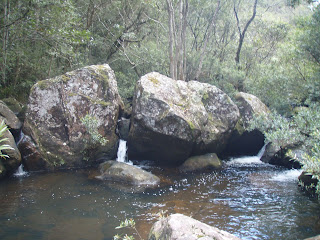
Its a mixture of cliffs, steep ravines, rocks, boulders and of course fast flowing water. The flora is a variety of rain forests, moss and lichen, in areas of little or no sun, then dry timbers, cut grass and scrub on the more exposed faces. Its a variety that's dense, with heavy ground cover and mulch, often hiding holes and holes.
A Bandicoot digging. The angle and shape is particular to them.
The walk to the Burralow via Wool Wash Creek becomes a little difficult as you approach the junction of the two. It includes a degree of rock hopping, fallen tree crossing and quite a bit of pushing through the undergrowth, (like a rugby player). Both crawling under, and over, wet and slippery terrain.
Remains of old convict road construction.
With recent fires having severely burnt some sections, for the first time I could see where the old convict roads retaining walls were. Rock overhangs and caves were also a feature.Within a short time we had arrived the junction and it was time to push north.
Sculptured rock caves are a feature.
The remainder of the walk to the campground is difficult. Many times we were force to crawl under, or over the undergrowth. In some sections moving forward became impossible and we had to beat a retreat, our footing unassured, metres could take hours.
Lichen covered matters of rock where the sun rarely shines. Incredibly soft and quite beautiful.
At one point we had reached a deep section of the creek with cliffs either side. There was no way over the top, and no way to guess the depth. Our only chance was to swim. Like Bear Grylles we set ourselves the task of swimming the 30 metres upstream to where a small beach appeared. The water was so cold, within a few strokes my breath was taken away and I could feel my body slowing right down. I felt I could have nearly "missed". This was canyoning.
Water Hole at Junction.
On reaching the beach we dried our clothes, had lunch and made some choices. The only way on the western bank was up. Let me tell you, there was little or no chance of walking. Fire had destroyed most of the trees and water bombing had flattened the undergrowth into a cross hatch of awkwardness. Most of this climb was on hands and knees, as rocks began to fall and the burnt soil was unstable.
After time we reached the top and could see our destination, which required us to head north and descend to the junction of yet another unnamed creek and again into cut grass and scrub. By this time my forearms were quite cut up and bleeding a lot and my dammed ankle was starting to ache like mad. Hours later, we arrived at the junction of the fire trails. A steep ascent was required to return to the Bowen Mountain Observatory.
Climbing to the top was the only way of getting a real perspective
Minor injuries are easy to obtain as you push through the bush, and slide down rocks. Careful placement of feet and hands and always planning ahead ensure that the risk of twists and breaks are reduced. This is not a walk that you could help via a vehicle.. If stuck- it's a helicopter ride.
An example of heavy scratches from sliding down a boulder face.
I had run out of water and needed to concentrate of putting one foot in front of the other as we headed home. A most rewarding, albeit difficult walk, one I certainly will never forget and not for the inexperienced.
Birds seen:- um..... frankly who cares!


